

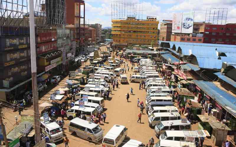
An aerial view of Nyeri Town main terminus, on April 27, 2023. [File, Standard]
Nyeri Town, situated approximately 150 kilometres north of Nairobi, serves as the administrative headquarters of Nyeri County. Historically, the town emerged during the colonial era as a British administrative post, gradually expanding to accommodate settlers, missionaries, and traders. Its evolution into a regional hub has been shaped by both historical functions and the surrounding natural systems.
Nyeri’s CBD has developed within a constrained geographical setting, heavily influenced by the Chania and Muringato rivers, which traverse the town in an east-west orientation. These river systems have dictated the alignment of the road network, resulting in a predominantly linear structure with limited room for lateral expansion.
Key east-west corridors namely Kenyatta Road, Gakere Road and Kimathi Way form the spine of intra-CBD movement. The western boundary is defined by Stanley Mathenge Road which connects to the Nyeri–Kamakwa Road, while the eastern edge is framed by Temple Road, extending toward Addis Ababa Road and Michezo/Hospital Road.
Follow The Standard
channel
on WhatsApp
This configuration has led to a compact and congested urban core, with limited capacity to absorb increasing vehicular and pedestrian traffic. The natural barriers, coupled with historical land use patterns, have restricted spatial flexibility, reinforcing the need for strategic decongestion interventions. These may include decentralisation of key services, development of satellite nodes and reconfiguration of transport infrastructure to enhance mobility and reduce pressure on the CBD.
Under the stewardship of the Governor, Dr Mutahi Kahiga, Nyeri County took a major step towards solving its congestion problem by constructing Field Marshal Muthoni Kirima Terminus, a new transport hub designed to ease pressure on the busy town centre. With the town sitting along major service roads and serving as the county’s headquarters, traffic has steadily grown, making its CBD overcrowded and difficult to navigate. This new terminus will spread out movement and create space for better planning.
This approach follows global and local goals to make towns more organised, walkable and easier to live and work in. By focusing on transport logistics as a tool to guide growth, Nyeri will become cleaner and more balanced in future.
Rationale for expansion of Nyeri town CBD: The CBD’s overextended functions, expanding administrative, commercial and public service demands have resulted in pronounced congestion within public spaces, with indiscriminate parking and limited pedestrian infrastructure. This situation has now reinforced the perception of Nyeri, both locally and countrywide, as a transit terminus rather than a structured urban node. These circumstances, as they currently stand, have continued to undermine the quality of urban life and strained the town’s capacity to deliver efficient services.
Geometric expansion towards the available eastern areas of the town remains constrained. Institutional grounds and underutilised parcels such as the former ‘Asian Quarters’, still present significant spatial voids and limited organic expansion. The lack of mixed-use development and integrated planning in these areas continue to further stifle connectivity and economic vibrancy.
In order to strategically address these challenges, the following was proposed—reconfiguring land use to promote mixed-use development and optimise underutilised public spaces, enhancing mobility and access through structured parking, pedestrianisation and multimodal transport integration and decentralising core functions to emerging nodes, thereby relieving pressure on the CBD and fostering balanced urban growth.
Such interventions do not only decongest the town centre, they also align Nyeri County’s spatial development with broader planning frameworks including the ISUDP, CIDP and Vision 2030.
Key targets under SDG 11 that are relevant to Nyeri town include target 11.2 (Providing access to safe, affordable, accessible and sustainable transport systems for all), Target 11.3 (Enhancing inclusive and sustainable urbanisation through participatory planning and integrated development) and Target 11.6 (Reducing the adverse environmental impact of cities, including congestion and pollution).
The Nyeri Integrated Urban Development Plan 2014–2034 operationalises these global aspirations by proposing targeted interventions to restructure and revitalise the town’s urban form. Among its key proposals is the adoption of Transit-Oriented Development (TOD) principles, which aim to concentrate mixed-use development around high-capacity transport nodes to reduce reliance on private vehicles and enhance walkability.
One notable TOD intervention is the Field Marshal Muthoni Kirima Transport Terminus, envisioned as a strategic mobility hub that can absorb overflow from the congested CBD, facilitate modal shifts and catalyse economic activity in adjacent zones. This aligns with the broader ISUDP goals of decentralising urban functions to reduce pressure on the CBD, promoting compact, connected growth through integrated land use and transport planning and enhancing public space utilisation and environmental stewardship. By leveraging SDG 11 and the ISUDP as guiding frameworks, Nyeri town is pursuing a structured decongestion strategy that is both locally responsive and globally aligned.
Nyeri town occupies a strategic position along key transit corridors, notably the A2 and B4, which are complemented by a dense local road network radiating from the town centre, which is the administrative and economic nucleus of Nyeri County, and the principal urban node in Central Kenya.
Given this locational advantage, transport infrastructure plays a pivotal role in facilitating access to economic, educational and social opportunities. To harness this potential sustainably, future spatial frameworks must adopt a mutually beneficial approach where urban growth is symbiotically nourished by mobility systems and vice versa. This concept envisions transport not merely as a conduit, but as a catalytic nutrient stream that sustains and shapes urban form, land use and socio-economic vitality.
In alignment with TOD principles, Nyeri’s future urban morphology prioritises compact, mixed-use development around intermodal transport hubs and walkable and connected neighbourhoods that reduce car dependency and enhance public space utilisation.
Integrated land use and mobility planning to curb suburban sprawl and mitigate traffic congestion. This reciprocal model reinforces the idea that well-structured transport systems can actively feed urban growth stimulating densification, economic clustering and inclusive access. By embedding TOD strategies within this mutual-benefit framework, Nyeri can evolve into a resilient, efficient and people-centered urban system that aligns with both local aspirations and global sustainability goals.
Decongesting Nyeri town is more than a physical intervention. It is a strategic reimagining of how this town functions, grows and connects. The new terminus signals a bold shift toward integrated urban planning, where transport infrastructure becomes the backbone of spatial transformation. Nyeri County wants to lay a strong foundation for a more balanced, accessible, and future-ready urban system. This is not just about easing traffic, it’s about creating a town that works better for its people, its economy and its legacy.
Follow The Standard
channel
on WhatsApp
By Beatrice Koech